


.svg)
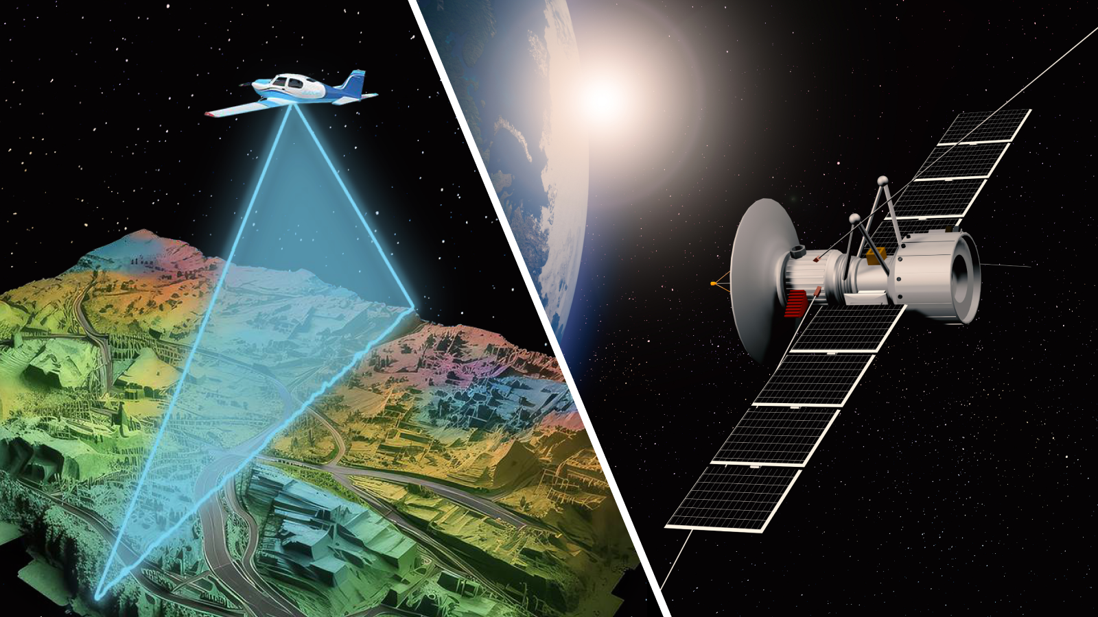
SATELLITE IMAGERY VS MANNED AERIAL SURVEYS: A Practical Guide to Choosing the Right Mapping Solution
News |
Feb 4, 2026
INTRODUCTION:
Welcome to this blog, where I explore the exciting world of geospatial technology focusing on two popular methods of observing the Earth: Satellite Imagery and (manned) Aerial Survey. These technologies are transforming industries such as urban planning, environmental monitoring, infrastructure development, and emergency response.
I will start by introducing the basics of what Satellite Imagery and Aerial Mapping actually are, before diving into a detailed yet digestible comparison of their advantages, limitations, and best use cases. This blog is especially intended for those who are new to the field perhaps students, early-career professionals, or anyone curious about how Earth observation works. My goal is to break down the differences, strengths, and ideal uses of each method in a clear and practical way.
Let’s start with a note of realism: both satellite imagery and manned aerial survey technologies are vast fields. Each deserves its own in-depth discussion, and entire volumes have been written on them. But in this blog, I aim to keep things simple focusing on key concepts and applications without overwhelming you with technical jargon.
With nearly 25 years in the geospatial industry (yes, long enough to remember when paper maps were the gold standard), I have worked across a wide range of projects from satellite imagery analysis and GIS mapping to hands-on spatial data collection. Since 2009, my focus has increasingly shifted toward aerial mapping, often trading the office chair for flight planning, and gaining a strong foundation in both technologies.
Through this blog, I would like to share insights from those years in the field clarifying the strengths, limitations, and best-use scenarios of satellite imagery versus manned aerial surveys and I hope this post provides some clarity, sparks curiosity, helps you navigate the options and maybe even avoid a few common detours.
Enjoy the read,
Engr. Usman Khan – Geomatics Consultant
CEO & Managing Director
Advanced Aerial Mapping Services Ltd.
WHAT IS SATELLITE IMAGERY?
Satellite imagery refers to photographs of the Earth captured by imaging satellites orbiting at various altitudes above the Earth’s surface. Satellite imagery plays a vital role in how we observe and understand our planet. These images are captured by satellites equipped with sophisticated sensors as they orbit the Earth at various altitudes. By collecting data across different wavelengths such as visible light, infrared, and radar, these satellites provide detailed insights into the Earth’s surface and atmosphere.
TYPES OF SATELLITE IMAGERY:
Satellite imagery used for mapping comes in various types, each suited to different applications depending on resolution, spectral range, revisit time, and purpose. Here's a breakdown of the main types of satellite imagery used in mapping:
PANCHROMATIC IMAGERY
- Description: Black-and-white imagery that captures a broad range of wavelengths in a single channel.
- Use in Mapping: Provides high spatial resolution (e.g., 0.3–1 m), ideal for detailed base maps, feature extraction (roads, buildings), and urban planning.
- Example Satellites: WorldView-2, GeoEye-1, BJ-3 (Beijing-3)
MULTISPECTRAL IMAGERY
- Description: Captures data in multiple specific wavelength bands (visible to near-infrared).
- Use in Mapping: Excellent for land cover classification, vegetation mapping, hydrology, and geological surveys.
- Example Satellites: Sentinel-2, Landsat-8, WorldView-3
HYPERSPECTRAL IMAGERY
- Description: Records hundreds of narrow spectral bands across the electromagnetic spectrum.
- Use in Mapping: Ideal for mineral mapping, crop health analysis, and environmental monitoring due to its spectral precision.
- Example Satellites: EnMAP (Germany), PRISMA (Italy)
SYNTHETIC APERTURE RADAR (SAR) IMAGERY
- Description: Active radar-based system that can capture imagery day or night, regardless of cloud cover.
- Use in Mapping: Suitable for topographic mapping, flood monitoring, surface deformation, and terrain change detection.
- Example Satellites: Sentinel-1, TerraSAR-X, RADARSAT-2
THERMAL INFRARED IMAGERY
- Description: Captures heat signatures emitted by surfaces.
- Use in Mapping: Used for urban heat mapping, geothermal surveys, and water stress analysis.
- Example Satellites: Landsat 8 (TIRS sensor), ECOSTRESS
STEREO AND TRI-STEREO IMAGERY
- Description: Pairs or triplets of images captured from different angles.
- Use in Mapping: Enables 3D terrain modelling, creation of DSM/DTM, and building height extraction.
- Example Satellites: Pleiades, WorldView-3, SPOT-6/7
SATELLITE-DERIVED BATHYMETRY (SDB)
- Description: Uses satellite imagery and algorithms to estimate water depth based on light penetration and seabed reflectance.
- Use in Mapping: Ideal for shallow-water coastal mapping, marine habitat monitoring, and navigation chart updates.
- Benefits: Global coverage, rapid data acquisition, and reduced operational costs compared to vessels or shipborne surveys.
HIGH-RESOLUTION COMMERCIAL IMAGERY
- Description: Offers very high spatial resolution (<1m), often for commercial applications.
- Use in Mapping: Urban planning, infrastructure development, asset monitoring, cadastral mapping.
- Example Providers: Maxar (WorldView series), Airbus (Pleiades), PlanetScope, Beijing-3 Satellite Constellation (BJ3A and BJ3N).
- Optical Imagery: Captures light in the visible and near-infrared spectrum (e.g., for vegetation analysis).
- Radar (SAR): Active sensors that emit signals and measure reflections, useful even in cloudy or night conditions.
- Multispectral/Hyperspectral: Capture data in multiple wavelength bands for advanced analysis (e.g., land use classification, mineral exploration).
KEY CHARACTERISTICS:
- Captured from orbits ranging from ~300 km (Low Earth Orbit) to 36,000 km (Geostationary).
- Offers wide-area coverage (100s to 1,000s of km² per image).
- Revisit time depends on the satellite’s orbit and imaging schedule.
- Resolutions range from coarse (10–30 m) to high (30–50 cm).
- For SDB Multispectral Optical 3–5 m resolution.
COMMON USES:
- Environmental monitoring
- Urban expansion analysis
- Disaster response and damage assessment
- Agricultural monitoring
- National-scale mapping
- Shallow-water coastal mapping
WHAT IS AERIAL IMAGERY (MANNED AIRCRAFT)?
Aerial imagery from manned aircraft refers to high-resolution geospatial data collected using specialized cameras or remote sensing instruments mounted on specialized Aerial Survey aircraft or helicopters. Unlike satellite imagery which is acquired from fixed orbital paths in space, manned aerial imagery is captured from lower altitudes, typically ranging between 500 to 5,000 meters above ground level.
This lower-altitude operation enables significantly higher spatial resolution and greater positional accuracy, making it particularly valuable for projects that demand fine detail. Manned aircraft can be deployed on demand and follow custom-designed flight paths, allowing for precise coverage of targeted areas at optimal times, whether for seasonal conditions, specific lighting, or minimal cloud interference.
Additionally, manned aircraft can carry multiple sensors simultaneously, allowing them to capture different types of data in a single flight. Some survey aircraft have two hatches; one can be used for a photogrammetric camera and another for a LiDAR sensor integration. This setup enables the collection of both imagery and LiDAR data at the same time, providing a detailed and comprehensive view of the terrain and built environment.
Using manned aircraft equipped with large, high-quality sensors is a key method for acquiring high resolution geospatial data. It offers accurate and flexible solutions for mapping areas of any size or complexity. Depending on the project’s goals, various aerial survey methods and sensor combinations can be selected to achieve the best results.
It's important to note that in this blog, the comparison does not include drone (UAV) technology. While drone surveys have their own unique advantages and limitations, I consider them a distinct category of data collection, that maybe explored separately in details in a future blog post.
Let’s start by exploring the most commonly used types of aerial surveys in professional mapping. Each uses different technologies to capture accurate geospatial data. Knowing these survey types helps you pick the best method for your needs.
TYPES OF AERIAL SURVEY
- PHOTOGRAMMETRIC AERIAL SURVEY
Photogrammetric aerial surveys use high-resolution cameras mounted on manned aircraft to capture overlapping images of the terrain. These images are processed to create accurate 2D maps and detailed 3D models, supporting several applications. The flexibility of manned aircraft allows for large-area coverage with high spatial accuracy when combined with ground control points.
- Technology: Large-format digital aerial cameras (e.g., Vexcel UltraCam, PhaseOne, IGI UrbanMapper-2, Leica DMC)
- Output: Orthophotos, Digital Surface Models (DSMs), Point cloud, Digital Terrain Models (DTMs), 3D City Models
- Use Cases: Urban planning, cadastral mapping, infrastructure projects
- Features:
- Captures overlapping stereo imagery
- Enables 3D modelling and topographic mapping
- High positional accuracy with ground control points (GCPs)
- LiDAR (LIGHT DETECTION AND RANGING) SURVEY
Manned aircraft equipped with LiDAR sensors emit laser pulses to precisely measure distances, enabling the creation of highly accurate, high-resolution 3D models of the Earth's surface and terrain features.
- Technology: Airborne laser scanners (e.g., RIEGL VQ-1560 II, Leica ALS series)
- Output: Point clouds, Digital Terrain Models (DTMs), vegetation penetration data
- Use Cases: Flood modelling, forestry, corridor mapping (e.g., power lines, roads)
- Features
- Captures precise elevation data, including ground under canopy
- Day/night operability
- Extremely high vertical accuracy (often <10 cm)
- OBLIQUE AERIAL SURVEY
In this survey, manned aircraft equipped with high-resolution oblique imaging sensors capture angled photographs of buildings and terrain. By acquiring images at oblique angles, typically between 30° and 60°. This technique enhances spatial understanding of complex urban environments and vertical structures.
The resulting datasets support advanced 3D reconstruction, façade mapping, digital twin, and detailed structural analysis, making it highly effective for urban planning, architectural documentation, and infrastructure inspection.
- Technology: Multi-angle camera systems (PhaseOne PAS 880, Vexcel Osprey, IGI UrbanMapper, typically 4 oblique + 1 nadir)
- Output: 3D textured mesh, façade imagery, immersive city models, Digital Twin
- Use Cases: Smart city modelling, urban visualization, property assessment
- Features:
- Captures images from 40–45° angles
- Enables 3D modelling with visible facades and structures
- Ideal for urban environments
To understand more about oblique imagery, its capture techniques, advantages, and applications, please refer to my previous blog titled "Vertical Imagery vs. Oblique Imagery" available on our website.
- AIRBORNE BATHYMETRIC SURVEY
Airborne bathymetric surveys use Airborne LiDAR (Light Detection and Ranging) systems to measure shallow water depths and coastal terrain from low-flying aircraft.
These systems can penetrate water using green laser wavelengths and generate precise 3D bathymetric data.
- Technology: Green-wavelength bathymetric LiDAR (e.g., RIEGL VQ-880-G, Leica Chiroptera 4X, CZMIL)
- Output: High-resolution bathymetric point clouds, Digital Terrain Models (DTMs), shoreline vectors
- Key Features:
- Measures shallow water depths and submerged features
- Complements satellite-derived bathymetry (SDB)
- Higher accuracy than SDB in complex or turbid waters
- Effective in shallow and nearshore areas
- Fast data collection over large areas
- THERMAL AERIAL SURVEY
Manned aircraft equipped with thermal infrared sensors capture emitted heat radiation from the Earth's surface. This method produces high-resolution thermal imagery that reveals temperature variations across terrain, infrastructure, and vegetation.
It is commonly used for heat loss detection, wildfire monitoring, environmental assessment, and geothermal exploration. Thermal sensors operate effectively both day and night, providing valuable data for energy audits, hazard identification, and ecosystem health analysis.
- Technology: Infrared/thermal imaging sensors
- Output: Thermal maps, heat loss analysis, environmental monitoring data
- Use Cases: Utility inspections, solar panel monitoring, wildlife surveys
- Features:
- Detects temperature variations
- Often used in conjunction with RGB or LiDAR data
- MULTISPECTRAL & HYPERSPECTRAL SURVEY
A Multispectral & Hyperspectral Survey conducted from manned aircraft captures reflected sunlight across multiple (multispectral) or hundreds (hyperspectral) of narrow spectral bands extending far beyond the visible spectrum. This high spectral resolution allows for the precise detection, classification, and analysis of surface materials and environmental conditions.
- Technology: Manned aircraft equipped with advanced imaging sensors, specialized cameras capturing across visible and non-visible spectral
- Multispectral Sensors: Capture data in 3–10 broad bands (e.g., Red, Green, Blue, NIR)
- Hyperspectral Sensors: Capture data in 100+ narrow bands across the visible to shortwave infrared spectrum
- Output: Vegetation indices (e.g., NDVI), land cover classification, Surface composition and material detection.
- Use Cases: Geology & Mining, Agriculture, Crop health monitoring, forestry, water quality analysis & precision farming.
Using manned aircraft for multispectral and hyperspectral surveys provides the advantage of high spatial and spectral resolution, custom flight paths, and the ability to respond quickly to project needs making it ideal for scientific research, resource exploration, and environmental management.
Overall, the flexibility, high resolution, and large sensor payload capacity of manned aircraft make them an ideal platform for a wide range of aerial survey applications including urban planning, topographic mapping, infrastructure monitoring, bathymetric surveys, and environmental assessments.
KEY CHARACTERISTICS:
- Ultra-high resolution (as fine as 2–10 cm per pixel).
- Can be planned to capture data at the exact time, location, and angle needed.
- Ideal for 3D modelling, infrastructure mapping, and engineering-grade accuracy.
- More flexible but requires airspace permissions and logistics planning.
COMMON USES:
- Urban planning and smart city modelling
- Road, rail, and utility corridor mapping
- Construction monitoring and asset management
- Digital Elevation Models (DTM/DSM) and point cloud generation
- Flood modelling and hydrological analysis
SUMMARY COMPARISON:
Below is a brief summary in the form of a table comparing satellite and aerial imagery. While many other factors could be considered, I’ve focused on a few key aspects to keep things simple and straightforward.
SATELLITE IMAGERY VS AERIAL IMAGERY - PROS & CONS
When it comes to acquiring geospatial data for mapping, planning, or environmental monitoring, both satellite imagery and aerial imagery (via manned aircraft) are widely used. Each method offers unique strengths and limitations depending on the project's objectives, budget, area size, and required resolution.
Continuing in this article, we will explore the pros and cons of both methods to help users better understand them and guide decision-makers in choosing the best option for their needs.
Here’s a pros and cons table for Satellite Imagery:
Here’s a pros and cons table for Aerial Survey Imagery:
CHOOSING THE RIGHT APPROACH
The decision to use satellite imagery or aerial imagery for each project is largely depends on the specific goals of the project. Each method offers distinct advantages and is best suited to different tasks. Understanding these differences will help choose the right approach to meet the project’s needs effectively.
Below is a table outlining some of the key criteria or goals to consider when making your decision:
The decision to use satellite imagery or aerial imagery is largely driven by the specific goals and requirements of your project. While both methods offer valuable insights, each has distinct advantages that make them more suitable for particular tasks. Understanding these differences is crucial for selecting the right approach to meet your project’s objectives.
To guide your decision-making process, several factors should be considered, such as the scale of the project, required resolution, budget, and the type of data is required.
CONCLUSION
Satellite and Aerial imagery both play key roles in geospatial world. Satellites are ideal for covering large areas, conducting regular monitoring, and when working with limited budgets. On the other hand, manned aerial surveys are better suited for projects that require high-resolution images, precise accuracy, 3D models, and LiDAR datasets. By understanding how these factors impact your project, you can make an informed decision about which method to use.
For example, if you're working on a project that requires large coverage and frequent updates, satellite imagery may be your best option. However, if you need high-resolution data for a smaller, more intricate area, an aerial survey using manned aircraft might be the ideal choice.
At AAMS, we help our clients navigate these choices to match the right technology with their project needs. Whether you are surveying a corridor, a city block or an entire province, our team can recommend the most effective solution.
Need help choosing the best data source for your next project?
Contact us at info@aams-sa.com or visit www.aams-sa.com for more information.
Related News
all News
.svg)


