3D laser scanner on a tripod capturing a building and its surroundings
  1. Home
  2. Services
  3. 3D Laser Scanning, BIM Integration & Digital Twin Development

3D Laser Scanning, BIM & Digital Twin Development

High-accuracy 3D laser scanning, BIM integration and digital twin development for facilities, infrastructure and industrial plants.

Enquire Now

Overview

Turning Complex Assets Into Intelligent Models

AAMS delivers high-accuracy 3D laser scanning, BIM integration and digital twin development by converting complex assets, including facilities, infrastructure and industrial plants, into photorealistic, survey-grade 3D models.

Our service supports as-built validation, facility condition assessment, space planning and real-time operations management. With point cloud processing and semantic annotation, we help clients build intelligent digital twins for optimized maintenance, planning and decision-making.

  • Terrestrial laser scanning
  • Mobile & handheld scanning
  • Point cloud processing
  • Scan to BIM
  • As-built validation
  • Semantic annotation
  • Photorealistic 3D models
  • Digital twins

3D

Survey-grade models of existing assets

BIM

Scan to BIM models for design and operations

Twin

Digital twins for maintenance and planning

Richdata

Semantic annotation of every key component

What we deliver

Core Capabilities

From the first scan to a living digital twin, each stage builds a more useful and accurate representation of the asset.

01 / Capture

High-Accuracy 3D Laser Scanning

Terrestrial, mobile and handheld laser scanners capture millions of precise measurements of buildings, plant, structures and sites, recording the true as-built condition of even the most complex environments.

Combined with high-resolution imagery, scans produce photorealistic, survey-grade point clouds that form a reliable foundation for design, refurbishment and asset management.

  • Terrestrial scanning
  • Handheld & mobile
  • Photorealistic capture
  • Survey-grade accuracy
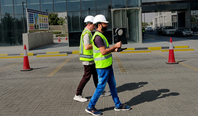
AAMS surveyors in safety gear operating a 3D laser scanner on site Laser scanning
02 / Modelling

Point Cloud Processing & Scan to BIM

Registered point clouds are cleaned, classified and converted into intelligent BIM models of architecture, structure and building services at the level of detail your project requires.

Scan to BIM gives designers and contractors an accurate model of existing conditions, reducing clashes, rework and surprises during refurbishment, extension and retrofit projects.

  • Point cloud registration
  • Scan to BIM
  • Architecture & MEP
  • Clash avoidance
Industrial warehouse shown alongside its point cloud and BIM documentation Scan to BIM
03 / Validation

As-Built Validation & Condition Assessment

Comparing scan data with design models confirms whether construction matches the design, identifies deviations early and supports handover and compliance.

For existing facilities, laser scanning supports condition assessments, space planning and documentation of plant and services, giving owners an accurate record of what is really there.

  • As-built validation
  • Deviation analysis
  • Condition assessment
  • Space planning
3D building services model highlighting piping and mechanical components As-built validation
04 / Digital twin

Digital Twin Development

Semantic annotation links each modelled component to information such as asset type, condition and maintenance history, turning a 3D model into an intelligent digital twin.

Digital twins support real-time operations management, predictive maintenance and long-term planning, and can be extended to entire campuses, cities and infrastructure networks using our aerial and mobile mapping data.

  • Semantic annotation
  • Asset information
  • Operations management
  • Predictive maintenance
Digital twin visualization of a city with buildings and data layers Digital twin

Applications

Where AAMS Delivers Value

Accurate 3D models and digital twins support decisions across the full lifecycle of buildings, plants and infrastructure.

  1. 01

    Facility Management

    Accurate as-built models and asset data for operations, maintenance and space planning.

  2. 02

    Refurbishment & Retrofit

    Existing-condition models that reduce design risk and on-site rework.

  3. 03

    Industrial Plants & Oil and Gas

    Detailed documentation of complex piping, equipment and structures.

  4. 04

    Construction Verification

    As-built validation and deviation reporting for quality control and handover.

  5. 05

    Heritage Documentation

    Precise digital records of historic buildings and sites.

  6. 06

    Infrastructure & Utilities

    3D models of bridges, tunnels, stations and utility assets.

  7. 07

    Smart Cities

    City-scale digital twins combining laser scanning with aerial and mobile mapping.

  8. 08

    Stadiums & Major Venues

    Digital twin asset records for lifecycle management and compliance.

FAQ

Laser Scanning & BIM Questions, Answered

Not sure which approach suits your project? Our team can recommend the right method, equipment and deliverables.

What is scan to BIM?

Scan to BIM is the process of converting laser scan point clouds into an intelligent Building Information Model (BIM). The model accurately represents existing architecture, structure and services, and is used for design, refurbishment, construction and facility management.

What is a digital twin?

A digital twin is an accurate digital representation of a physical asset, enriched with information about its components, condition and performance. It supports operations, maintenance planning and decision-making throughout the asset's lifecycle.

How accurate is 3D laser scanning?

Terrestrial laser scanning captures survey-grade measurements suitable for engineering design and as-built validation. Accuracy depends on the scanner, range, registration method and control, and is agreed with you at the start of each project.

What software formats do you deliver?

We deliver registered point clouds in standard formats such as E57, LAS and RCP, and BIM models in common formats including Revit and IFC. Formats and level of detail are confirmed at the start of each project.

Can you scan a facility while it is operating?

Yes. Laser scanning is non-contact and fast, so most facilities can be scanned with minimal disruption to operations. We plan scanning around access, safety and operational requirements.

Can digital twins cover a whole site or city?

Yes. We combine building-level laser scanning with aerial mapping and LiDAR survey and mobile mapping data to create digital twins of entire campuses, cities and infrastructure networks.

Start a project

Tell us about your next project.

Share your site, accuracy requirements and deliverables. We will recommend the right technology and workflow for the job.

Enquire Now